

Geographic coordinates
In geometry, it is a polar coordinates system that take reference the Earth rotation axis, the Greenwich meridian and the equator.
Let's go into details in order to better understand the matter.
We can start from an Earth image, and we can identify some useful elements.
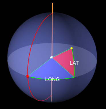
We can observe:
- Earth rotation axis going through the Earth from north to south
- Greenwich meridian (in red). Meridians are imaginary lines joining together north and south poles and going over the sphere surface. Greenwich meridian passes through the homonymous observatory in England.
- Equator level, that "cut" the Earth horizontally into halves.
- The interface between equator and Greenwich meridian is the origin of our system (red sphere).
Let's consider now the yellow sphere, and let's suppose we want to know its position as regards the red point. We can say that we have to move rightwards, (better eastwards), along the equator line, up to be under the yellow point, and then go northwards up to meet it.
For measuring these movements, we have not to use the meters running along the equator, but the angles. Looking at the previous image, we can see two sectors: the blue one (for horizontal movements) and the red one (for vertical movements).
The position of yellow point is therefore obtainable by two movements (or, better, angles): the one indicated by blue sector (eastwards) and the one indicated by red sector (northwards).
For making this information univocal, in addition to the angles we have also to know in which direction we move: this is obtained using cardinal points:
- East or West for blue sector
- North or South for red sector
Angles and directions now have specific names that we heard a lot of times:
in geographic coordinates we have in fact longitude (east/west) and latitude (north/south).
An example of coordinates can be:
LONG: 15° E
LAT: 45° N
This means that for reaching the position indicated by these coordinates (starting from origin) we have to move 15° eastwards and 45° northwards
How to write angles
Longitude is expressed with an angle variable between 0° and 180° (W/E), and latitude between 0° and 90° (N/S).
Angles can be expressed in three different ways:
1) using degrees, tenth of degrees, cents of degrees, etc.
2) using degrees and primes
3) using degrees, primes and seconds
For passing from one form to another, it is necessary to remember that 1° are 60' and 1' are 60" (1 hour is 60 minutes, and one minute is 60 seconds) and then we can make the conversion.
Let's make an example using the previous angles:44°30'45"
Since as for having 1' we need 60", we can say that:
45" are equal to 45/60 primes = 0,75'
The starting angle can be therefore as 44°30,75'
Going on with the same method, we know that for having 1° we need 60 primes
So 30,75' is corresponding to 30,75/60 degrees, and so 0,5125°
The starting angle can be therefore as 44,5125°
The opposite way is as much simple:
44,5125° can be divide into:
The entire part is ok: 44°
We have to divide 0,5125°: since as 1° are 60', then:
0,5125° are equal to 0,5125*60'= 30,75'
So we can say the new coordinates as 44°30,75'
In the same way, we can say that 30,75' = 30'+0,75'
And, as previous mentioned, 0,75*60 =45", obtaining again 44°30'45"
At last, we can say that geographic coordinates are often used for their extremely precision and easy use. They are also convenient at macroscopic level, because starting from any couple of coordinates LAT,LONG, we are immediately able to know in which zone of the Earth we are.
For what is concerning short distances, geographic coordinates are a little more uneasy. In fact, supposing to have our position and the position of another point that we want to reach: comparing the coordinates we are able to know in which direction we have to move, but not the distance to be covered.
Thanks for reading this article. If you want, you can give your opinion using the voting menu at the beginning of this page. This will help us to improve our website!