

UTM Coordinates
UTM coordinate system is generally used in map-making (e.g. in Italian Military Geographic Institute).
It is based on dividing the earth surface in many different zones using the meridian and parallel net. (In detail, taking reference Greenwich meridian and equator, we can create a net with one meridian every 6° longitude and one parallel every 8° latitude).
This net does not cover entire earth surface, it goes as far as 80°, leaving out the poles. Therefore we obtain a net of 60x20 elements, each 6° "width" and 8° "height", as per the following picture.
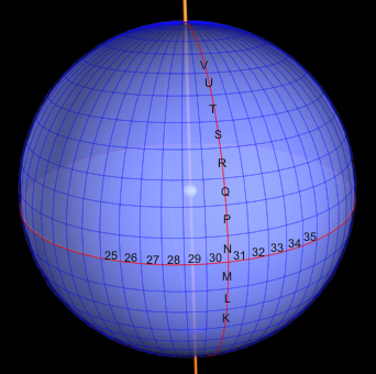
In order to distinguish each zone, it is assigned a number from 1 to 60 to horizontal sectors (Greenwich meridian divides section 30 from 31) and a letter to vertical section (from south to north, from letter C to X, excluding letters I and O, due to their possible confusion with number 1 and 0.
Let's note that the first zone northwards to equator is just named "N").
In this way, each zone can be univocally defined using one number and one letter (e.g. 32T zone).
Then, a position expressed in UTM coordinates will have identification zone as first value: we have now to discover the coordinates inside each zone.
First, let us consider the zones in particular.
As previously mentioned, each zone is 6° "width" and 8° "height", but if we can measure the width in meters, we should find that it decreases while we come near the poles (the zone become narrower).
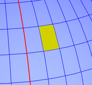
Therefore, zones in different latitude will have also different shapes, an this is not useful for having a coordinate system applicable to each zone.
This matter is solved projecting each zone on a cylindrical surface. This kind of projection distorts, or better "stretches" each zone, making it "conformed".
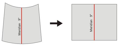
Practically now we have a map where movements from north to south (Y axis) are always perpendicularly to the movements from east to west (X axis), in any point of the zone.
Besides, in the printed maps, scale factors of each axis are the same: this for allowing us to measure the distance between two points using a simple ruler, or using the division into squares, quite always present in this kind of maps.
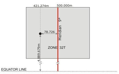
For each zone we take as datum point the central meridian (if the zone is from 6° to 12° longitude we take 9° meridian) and equator line.
Coordinates of one generic point inside the zone are taken using two values named "east" and "north". These values indicate of how much meters we have to move to east direction (as regards the central meridian) and to north direction (as regards the equator), in order to locate our position.
In order to avoid negative numbers, it is assigned the value of 500000 meters to the meridian passing in the centre of the map. In the same way, it is assigned a conventional value of 0 meters to the equator (for zones northwards the equator) or a value of 10000000 meters (for zones southwards the equator).
For making an example, let's consider the top of "Galero" mountain. This has the following geographic coordinates:
44°09'22"N
8°00'56"E
Transferring these values on UTM system, they become
32T , 0421274 east , 4889679 north
(conversion effected with GPS Garmin Etrex Summit)
The coordinates have to be red in this way:
map 32 T
distance 78726 meters from map central meridian (that is 500000 - 421274)
distance 4889679 meters from equator.
As you can see from the example, UTM single coordinate is not quite intuitive.
Generally UTM coordinates are not used for big distances (when we operate in many different zones), but they are very useful in local ambit, specially used in accordance with a map.
Let's imagine to know our position and to have the necessity to reach another point (of which we know the coordinates).
Comparing the coordinates of the two points we can discover in which direction we have to move and how much meters we have to walk. In a better way, if we have a map using UTM coordinate system, we can transfer these coordinates and then choose the best way to do.
Thanks for reading this article. If you want, you can give your opinion using the voting menu at the beginning of this page. This will help us to improve our website!